Phase II of the Piney Forest Road corridor study in Danville is well underway, following the conclusion of Phase I at the end of May. The purpose of the project is to evaluate multiple components of the 2.6-mile Piney Forest Road corridor, extending from Holt Garrison Parkway at the south end to Franklin Turnpike at the north end, and advance road safety recommendations, functionality, pedestrian and bike access, and transit improvements. While the Danville Metropolitan Planning Organization (MPO) is leading the effort, EPR Planning Consultants is conducting the majority of the work, with the MPO and the City of Danville performing some tasks as well.
Phase I began early in the year and included a safety assessment and an overview of the corridor’s functionality, in terms of how efficiently traffic moved. Access management (the number of vehicular access points on a given area along the corridor) was examined, as were existing bike, pedestrian, and transit amenities. Public input was also obtained via a MetroQuest survey as well as a virtual public meeting.
A significant part of Phase I involved the development of a number of recommendations for the corridor. Recommendations comprise access management strategies for specific property access points as well as for installation of medians, installation of crosswalks to improve pedestrian safety and comfort, the proposal for a parallel bike route, and a proposal for an additional transit shelter at a high-use stop along the corridor. For its part, MPO staff identified opportunities for parallel vehicular connections along the corridor, which primarily consists of inter-parcel connectivity to reduce the number of vehicles using Piney Forest Road itself. The image below depicts draft recommendations for the intersection of Piney Forest Road and Nor Dan Drive, as one example.
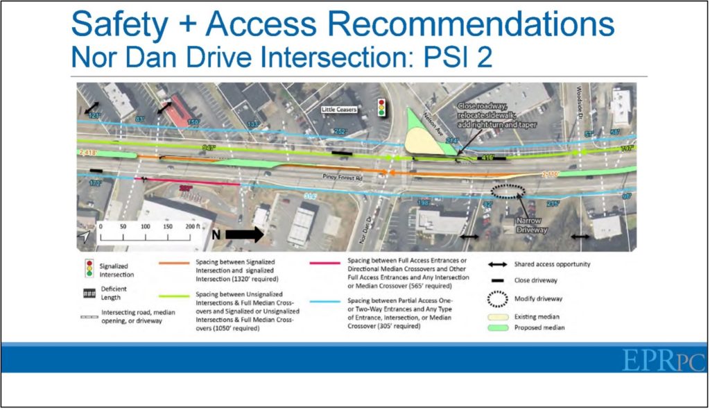
The recommendations depicted in the above image include proposals for center medians, driveway closures to enable the corridor to adhere to VDOT access spacing standards, inter-parcel connectivity, and the closure of one of two vehicular access points to Nelson Avenue and a sidewalk extension over the existing traffic island where the closure is proposed.
Phase II
Phase II of the Piney Forest Road corridor study began in late summer 2021, at about the time that updated traffic figures were released by VDOT. The reason for waiting for new figures to be released rather than utilizing earlier figures was that it was believed the figures released at the later date would be influenced to a lesser extent by COVID-19 than earlier time periods, which would likely have indicated lower than normal traffic flows.
As it had done during Phase I of the study, Danville MPO staff conducted work during Phase II as well. One Phase II task MPO staff conducted included a travel time analysis, which involved driving the entire corridor multiple times each during the AM and PM peak travel periods to determine the amount of time it would take for the average vehicle to drive the corridor. A related task undertaken by MPO staff included traffic queue analyses, in which staff counted the approximate number of vehicles backed up at traffic signals. The intent of this analysis was to determine how efficiently traffic signals were handling the corridor’s traffic flow.
Intersection Level of Service (LOS) analyses were also conducted by EPR. These analyses determine how well both signalized and unsignalized intersections are functioning based on an A – F scale, with A indicating free-flow conditions and F indicating very congested, inefficient vehicular movements. The analysis revealed that many of the left turns from Piney Forest Road onto side streets at signalized intersections were either E or F during the AM and PM peak hours; similar traffic movements at unsignalized intersections were found to function more effectively. Left-turning movements from many of the side streets – particularly at signalized intersections – also performed rather poorly.
An analysis of projected 2045 turning movements indicated a slightly improved LOS for many of the left-turn movements transitioning from Piney Forest Road onto side streets; projected turning movements from side streets onto Piney Forest Road were more mixed, however. The improved LOS figures are likely a result of an anticipated continuation of the City’s population decline over the next 20+ years, which would logically translate into fewer vehicle trips. Such a scenario must be approached with caution, though, as numerous developments are taking place in Danville that may reverse, or at least stabilize, that population decline. The new Caesars Virginia Casino, which will also include a hotel, dining establishments, conference facility, and live performance venue are anticipated to generate more than one-thousand new jobs for the Schoolfield area of the City, not to mention the influx of visitors. Additionally, the River District, involving the transition of the former largely industrial section near downtown into apartments, condominiums, and commercial establishments, has been very successful in attracting new residents and businesses to the City. The redevelopment of the White Mill into up to 250 apartments plus retail space, the development of the adjoining Riverfront Park, and the redevelopment of the building formerly housing Lou’s Antiques will attract a greater population and more investment to the City. Lastly, the development of the Southern Virginia Mega Site at Berry Hill will have an impact on the City, particularly by necessitating development and redevelopment of housing throughout the City to house workers and their families. These three developments have the potential to result in development and redevelopment throughout other parts of the City.
One of the next steps as part of Phase II of the Piney Forest Road study will involve the development of improvement concepts to address any identified deficiencies; this will take place during the winter months. Following this, early in 2022 will be a second MetroQuest survey and public input meeting to garner public input into the plan. Lastly, a final report will be developed early in 2022, following the public input.
To learn more about this study or to provide comments, please visit https://danvillempo.org/piney-forest-road-study/.